 Filter: Categories of Wisconsin Historical Images
Filter: FORMAT_DIMENSIONS of 29 x 37 cm
Filter: Categories of Wisconsin Historical Images
Filter: FORMAT_DIMENSIONS of 29 x 37 cm

| Date: | 1899 |
|---|---|
| Description: | This color map, originally published in the Smithsonian Institution Bureau of American Ethnology's 18th annual report, shows the Indian land cessions in Wi... |
| Date: | 1930 |
|---|---|
| Description: | Map shows prairie, oak, maple, oak and maple, marsh conifer, maple and beech, and grass and sedge. |
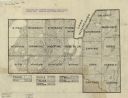
| Date: | 1900 |
|---|---|
| Description: | This Plat map shows the second location of Helena's (of three) on the banks of the Wisconsin River. It also shows the location of shot tower northeast of t... |

| Date: | 1776 |
|---|---|
| Description: | Fairly detailed map of New York City and parts of Long Island. It shows streets, roads, wharves, ferries, ship yards, Fort George and the battery, public b... |
If you didn't find the material you searched for, our Library Reference Staff can help.
Call our reference desk at 608-264-6535 or email us at: